


The way of the three seas
A ribbon 390 miles long. Uniting central Italy from West to South, and East. Going from dusk to noon and dawn. Touching three seas – the Tyrrhenian, the Ionian and the Adriatic – ça va sans dire, the heart of the Mediterranean. The Appian Way connects Roman civilization to the Magna Graecia and the Hellenic East.
Regina Viarum – as the poet Statius described it in the first century A.D. – is not much when you consider the full picture. Its miles are marked by millennia of wisdom, philosophy, mathematics, languages, sculpture, architecture, laws, war and peace, fertile fields and bustling ports, Crusaders, cowherds and shepherds, poetry and myth, excesses in vineyards and gulps of water at longed-for springs after a lonely walk of dust and sun. From Rome to Brindisi, via Taranto. Touching four regions (Latium, Campania, Basilicata, Puglia). The sea can be felt everywhere, even among the sheep-tracks of the Apennines, because it is the sea that is yearned for on the journey along the basalt road. Embarking for adventure, in search of fortune, be it the lands of the Near East or the Pillars of Hercules. Prayers are sent to the Gods, sails are hoisted, oars are pulled, perfumes and spices are brought from the Silk Road, loads of oil and peaches, fish and statues of heroes, like the two bronze warriors who ended up at the bottom of the sea in Riace.
The Appian Way connects Roman civilization to the Magna Graecia and the Hellenic East
The Appian Way knows too much, sublime and offended by building havoc. Paved and decorated with shopping mall billboards. But then it rewards us with burial sites in the Roman Campagna, temples, columns, triumphal arches, bridges. A melody that fascinated voyagers on the Grand Tour but immediately aroused feelings of passion and anxiety. For whilst its history begins in 312 B.C., when the censor Appius Claudius Caecus decreed its construction to connect Rome with Capua and provide the Urbs militia with rapid links to the battlefields during the Samnite Wars, its development goes beyond the fighting.
This most valued road, as it lengthened, became synonymous with relations and trade. After Capua, it reached Benevento, then Venosa and finally Brindisi. Climbing over and bringing to life hostile, arid or marshy lands. It was a miracle already perceived by Pliny: the Appian Way, he wrote, with its carpet of great stone slabs, overcame “that troublesome wetland like a true wonder, as if, to support the weight of those huge stones, another Hercules had drawn that great and solid embankment up out of the water.”
Staging posts (mansiones) for refreshing horses and riders become vivid stopping signs, placed as they are every ten miles. And with each day of travel, the overnight accommodation for changing mounts (mutationes) create the conditions for anthropogenic densification, which enriches the archaeological finds.
The twentieth century reinforces its function of connection. Three reclamation works wrest good land for cultivation in the Pontine Plain, the Agro di Falerno, and the Tavoliere delle Puglie. World War II freezes economic growth: plowed and sown fields become battlefields, bridges are mined and destroyed. But now those who cross it on foot – the route from Rome to Brindisi was traveled in 2015 by Paolo Rumiz, the subject of an inspiring diary, and recently by Giulio Ielardi, who captured on camera hundreds of shots from unconventional perspectives – in the journey from the Tyrrhenian to the Adriatic can observe a very wide range of variations in environment, ethnicity and landscape.
And the walk, suggests Simone Quilici (who directs the Appia Antica Archaeological Park and is overseeing a project to restore all 390 miles, even where the route is lost under paths, in fields, buried by asphalt and concrete) has the value of a progressive approach to Mediterranean culture.
The twentieth century reinforces its function of connection. Three reclamation works wrest good land for cultivation in the Pontine Plain, the Agro di Falerno, and the Tavoliere delle Puglie
So we too take some snapshots along this march toward the sources of identity of the Mare Nostrum, which then constitute the pillars of Western civilization. The sublime initial steps are universally known: the Tomb of Cecilia Metella, the villas of Maxentius, of Capo di Bove, of the Quintili with the church of Santa Maria Nova, while in parallel, on the Appia Nuova, the mighty arches of the aqueducts stand firm. Instead, we want to pause at the lesser-known points, but so charged with meaning.
At the XXXIII mile, at Piscina di Zaino, in the Pontine plain, we find the Tres Tabernae, right on the junction of the Appian Way with the road leading to Ninfa – the oasis garden among the ruins – and to Norba, perched with its protective walls on the Lepini Mountains. Thirty miles from Rome, it was the first mutatio. The road connecting to the sea at Anzio must have come from the west. The Acts of the Apostles state that a handful of Christians who had left Rome and Paul of Tarsus met here, on a “mission” to the Caput Mundi to spread the religion of Jesus from East to West, not escaping the beheading inflicted on them by Nero.
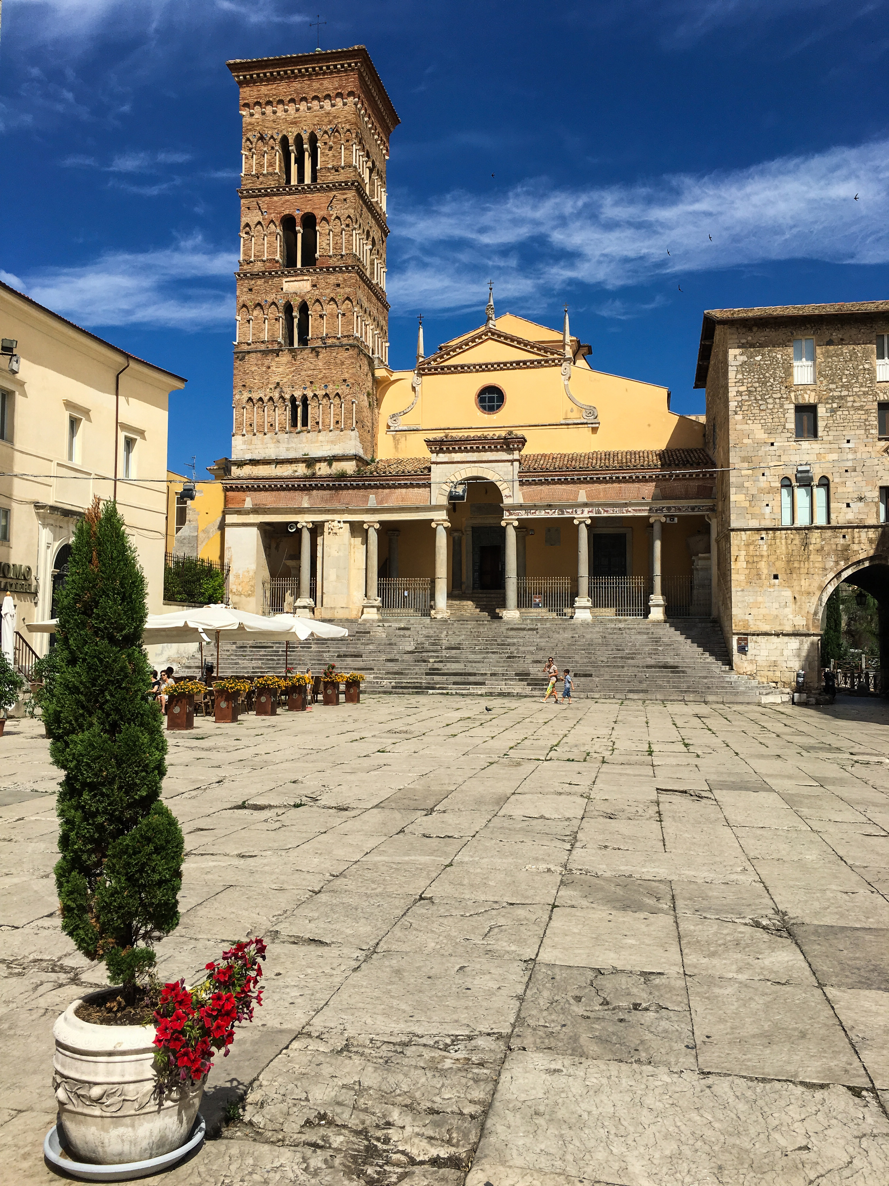
In Terracina, the Regina Viarum travels through the center of town. To the Town Hall Square and the Aemilian Forum, bordered on one side by the very slabs of the Appian Way, which still constitutes the structure from which the city was generated. Here, we reach the sea, but the vastness of the blue prevents us from looking away from the lofty Temple of Jupiter Anxur, which dominates the plain of Fondi and the arc of the coastline, down there in the sloping terraces and maritime pine forests. The port is lively however, though inferior in movement of goods to the port of Minturno, where the decumanus maximus meets the Appian Way. The city is both a seaport and a river port, as its beaches, stretching into the Gulf of Gaeta, reach the mouth of the Garigliano River.
And so, on the “route” of the Appian Way, we meet the bridges – three, to be precise – over the Garigliano: the 19th-century crossing built by Ferdinand II of Bourbon, another built in 1927 and the most recent, built in the 1990s. Miles further on, in Benevento, the humpback Ponte Leproso from the 3rd-century B.C., now passable only on foot, retains an original pier, with the stones assembled in opus quadratum and rustic ashlars. The Appian Way now ventures into the heart of the Apennines, Irpinia, and bends toward Basilicata.
The Appian Way now ventures into the heart of the Apennines, Irpinia, and bends toward Basilicata
It touches Horace's hometown of Venosa on the Potentino plateau, then reaches the border with Puglia, crossing the Ofanto River. It starts the descent toward the Ionian Sea, past farms and ravines. In Massafra there is one ravine dedicated to Our Lady of the Staircase: around the year 1,000, it was the stage of the magician Greguro, a magnetic healer, thanks to the collection of herbs that sprouted by the dozens in the protected habitat of the deep cleft. Taranto – excluding the disturbing hulk of the Ilva steelworks – boasts the crystal waters of both Mar Piccolo and Mar Grande, where fresh and salt water mix, giving a delicate flavor to the tender mussels farmed here. The Swing Bridge opens for the passage of large Navy ships, the two massive columns of the Archaic Doric Temple frame a strip of blue.
In Brindisi, another column, this one slender as a spear pointed skyward, marks the end of the Appian Way. It plays hide-and-seek with the narrow streets around the cathedral, but if you touch it, you feel as if you are brushing against the waves of the Adriatic that flow ahead of it, beyond the harbor. Ferries set sail for Corfu, Patras, Kefalonia, Zakynthos, Igoumenitsa. And for Vlora, Albania. The Mediterranean opens its arms wide.
Read

13 giugno 2024
13 giugno 2024
13 giugno 2024
Seguici su


